 Guest
Guest
Chapter:
1. Explain importance of Engineering geological system in context of Nepal.
Engineering Geological System is defined as a system constituting of all the components and features forming the earth's crust. The following are the importance of Engineering geological system to civil engineers in the context of Nepal:
- The knowledge of EGS enables a civil engineers to understand the geological features of an area so that the process of planning, safe design, and construction of civil engineering projects can be carried out effectively.
- Nepal is a country whose geology is characterized by the presence of many folds, faults, thrusts etc. EGS provides knowledge about all such features so that a sage design and construction of civil engineering projects can be carried out.
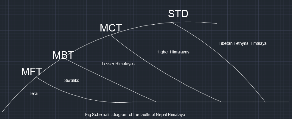
2. Explain Major Discontinuities (tectonic Zones) of Nepal Himalayas and ir Engineering Significance.
The Nepal Himalaya was formed by the collision of two continental plates: the Tibetan plate and the Indian Plate. It is believed that Indian plate is going down while Eurasian plate (i.e, Tibetan plate) is rising over the Indian plate.This action has generated the following major discontinuities parallel to the Nepal himalayas :
- Main Central Thrust (MCT)
- Main Boundary thrust (MBT)
- Main Frontal Thrust (MFT)
Main Central Thrust (MCT):
This is the tectonic contact between the Higher Himalayas and Lesser Himalayas. The MCT was active during the early phases of Himalayan orogeny but it is now considered to be less active than main boundary thrust (MBT). The maximum earthquake potential of this fault was recorded to be 7.5 in magnitude.
It is a north dipping thrust fault.
Main Boundary thrust (MBT):
This is the active tectonic contact between the Lesser Himalayas and Siwaliks. The MBT has been the source of very large earthquakes in the past. It is seismically most active thrust.The maximum earthquake potential of this fault was recorded to be 8 in magnitude.
It is a steep north dipping fault.
Main Frontal Thrust (MFT) or Himalayan Frontal Thrust (HFT):
This is the tectonic features located at the boundary of Siwaliks and the Terai. This fault is also considered active. The maximum earthquake potential of this fault is 6.5 in magnitude.Seismic risk is considerably less.
It is a also a north dipping fault.
Engineering Significances of Discontinuities:
- The thrust zones are weak, porous, unstable and incompetent and hence are most undesirable geological features that endanger the stability of engineering structures and also creates leakage problems.
- an active thrust occurring close to an engineering sites is vulnerable to earthquake and as such sites should be avoided from construction of any heavy structures.
- Thrust influences the movement of surface water , also causes the sudden change in the courses of rivers may be due to thrusting.
- These thrust zones are prone to landslides, rockfalls, debris flows, earth flows, mudflows etc.
3. Explain major engineering geological problems i.e, civil engineering challenges of Nepal HImalayas and ir mitigation.
For the development of various infrastructures within the entire country, Civil engineers may encounter various, quite unique and different geologic problems at specific sites of different geological zones during site selection, investigation, design and construction.
Engineering Problems Of Terai Region:
Talking about the geological hazards, since this zone is a plane area without noticeable relief change, landslides and associated hazards is not possible. This zone is mostly hazardous for flood. The problem of river channel shifting is very common here which is seen by the fact that bridge constructed over the river channel before are isolated from the present river channels in many places.In the terai zone, main problems for roads, bridges, and other engineering structures is flooding, river bank scouring, and liquefactions in various foundation works due to earthquake in the southern part. Similarly, at the northern part, the stream originating from siwaliks with their shallow and broad channels bring large amount of sediments and cause sudden flood during monsoon perion damaging roads, bridges, buildings, and other infrastructures. Some geological problems of this region are:
- Flooding,
- Liquefaction,
- Excessive sediment deposit,
- Earthquakes,
- Scouring of banks, piers, abutments etc.
- Subsidence
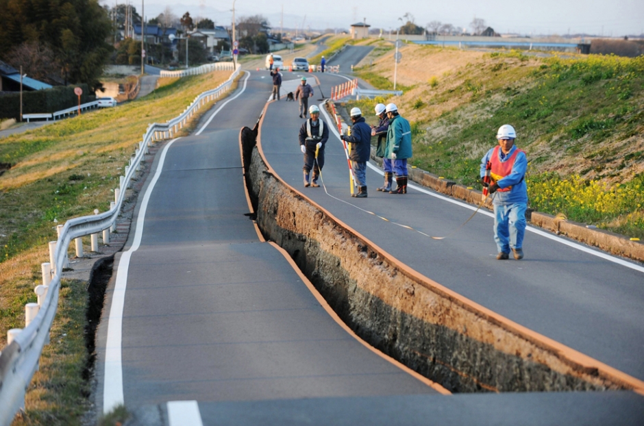
fig: liquefaction
Mitigation of these problems:
- flood can be controlled by planting vegetation, through the construction of leeves, lakes, dams, reservoir etc.. Moreover floodways can be constructed to divert floodwater.
- The civil engineers must think of making his construction immune to earthquakes.
Various ground improving techniques like compaction grouting, dynamic compaction, vibro compaction, vibro replacement, wet soil mixing etc. can be used to control liquefaction.
Engineering Problems Of Siwaliks Region:
Talking about the geological hazards, since this zone has noticeable releif change and steep, there is possibility of landslides and slope failures. Lower siwaliks is dominantly composed of weak mudstone, which are highly susceptible for weathering and therefore erosion is prominent in this zone. Simalarly, plain failure, wedge failure, and toppling failure are possible in middle siwaliks. Upper siwaliks consists of conglomerates, which after loss of cementing materials by weathering become vulnerable for slope failures and landslides. The streams and rivers can easily corrode these materials very easily ,as a result of which they carry large amount of sediments. Some geological problems of this region are:
- Landslides,
- Slope failure,
- Debris flow,
- Gully erosion,
- River cutting,
- Swamp and badland development in dun valleys,
- Stone extraction has led to creep of whole region.
Mitigation Of These Problems:
- various preventive (construction of retaining structures) and corrective measures (reduction of pore water pressure, slope reformation, protection of toes of slope from erosion etc.) can be applied to prevent landslides, creep flow , debris flow etc.
Engineering Problems Of Lesser Himalayas Region:
Highly jointed meta-sedimentary rocks along with numerous folds and faults in lesser himilaya zone accelerates the landslides and slope failure. Intense precipitation and high gradient of river in this zone accelerates the debris flow. The scale of such devastation brought by such debris flow in this region is huge as for example a bridge over was collapsed by debris flow as shown below. Some of the geological problems of this region are listed below:
- Landslides,
- Debris flow,
- Slope failure,
- Earthquake,
- Flash floods,
- Rock falling and rock toppling.
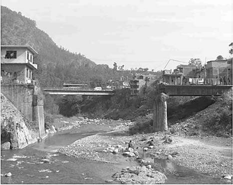
fig: Collapsed-bridge-over-Malekhu-Khola-Dhading-district-by-the-debris-flow.
Mitigation of these Problems:
- various preventive (construction of retaining structures) and corrective measures (reduction of pore water pressure, slope reformation, protection of toes of slope from erosion etc.) can be applied to prevent landslides, creep flow , debris flow etc.
- The civil engineers must think of making his construction immune to earthquakes.
- flood can be controlled by planting vegetation, through the construction of leeves, lakes, dams, reservoir etc.. Moreover floodways can be constructed to divert floodwater.
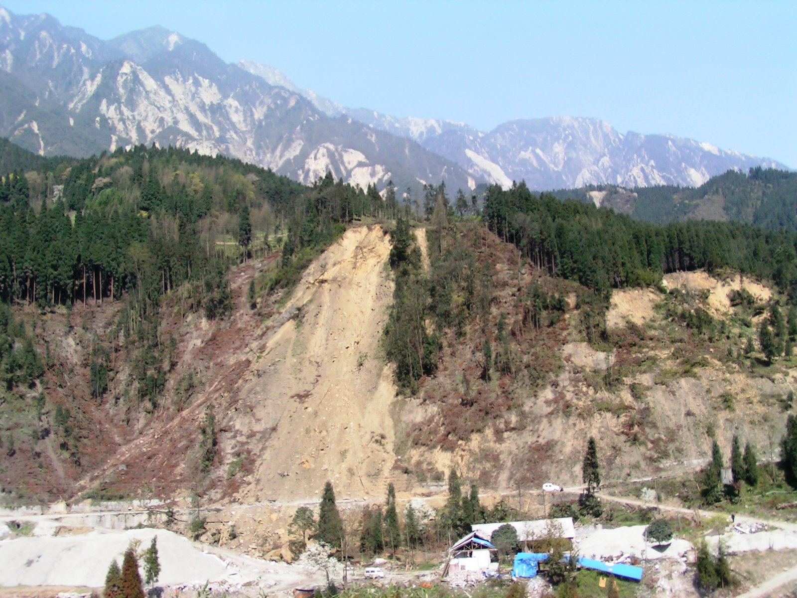
Engineering Problems Of Higher Himalayas Region:
The higher Himalaya of Nepal is exposed dominantly to rock falls, rock slides etc. as this zone is composed of hard crystalline metamorphic rocks with adverse orientation as well as many glacial lakes in threat of breaching. In many places landslides have dammed the deeply incised rivers contributing to landslides dammed outburst flood (LBOF), which is for example very common in kaligandaki valley. A glacial lake outburst flood (GLOF) is a catastropjic surge of water and debris caused by sudden outburst of glacial lakes. It creates serious problem for cultivated land, infrastructures etc. Glacial lakes in Nepal Himalaya are classified as: Moraine dammed lakes, Glacier ice-dammed lakes, and ice core-moraine-dammed lakes. The transportation of sediments during a GLOF is exceptionally great and materials is eroded from riverbanks, terraces, and slopes. As a result, several slope instabilities are triggered. (note: for the design of hydropower project, road in this zone vicinity of snow fed rivers, a civil engineers must consider these factors during site selection, investigation and design.) Some geological problems of this region are:
- Landslides,
- Debris flow,
- Slope failure,
- Earthquake,
- GLOF,
- snow avalanches,
- rock falls.
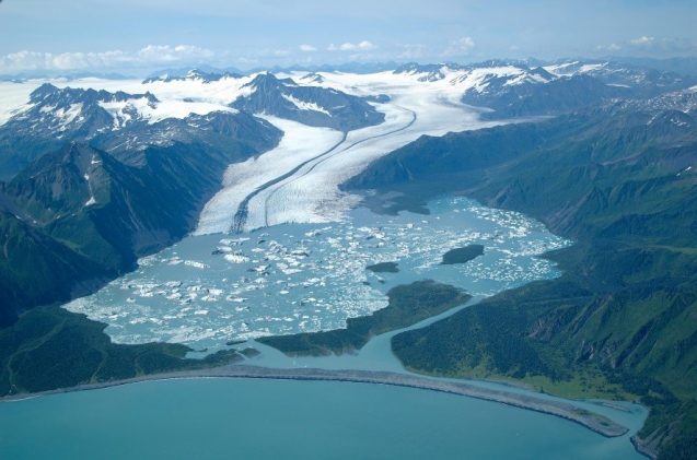
fig: glacial lake outburst.
Mitigation of these Problems:
- various preventive (construction of retaining structures) and corrective measures (reduction of pore water pressure, slope reformation, protection of toes of slope from erosion etc.) can be applied to prevent landslides, creep flow , debris flow etc.
- The civil engineers must think of making his construction immune to earthquakes.
Engineering Problems Of Tibetan Tethys Region:
It is located in the rain shadow area and therefore soil related landslides are not common in this area. This area consists of sedimentary rocks and in many places these rocks are weathered mechanically by snow to produce unconsolidated sediments. The wind blows so strong and therefore these unconsolidated sediments can be easily eroded. Typically this region is characterized by intense river bank erosion in the alluvial and glacial moraine deposits contributing to bank failure. Debris flow is common in snow fed rivers of this zone. Some of the geological difficulties of this zone are:
- Erosion due to high wind,
- Flash floods
- Debris avalanches.
4. Explain importance of EGS in context of Nepal.
Engineering Geological System is defined as a system constituting of all the components and features forming the earth's crust. Some of the importance of EGS in the context of Nepal are:
- The knowledge of EGS enables a civil engineer to understand the geological features of an area so that the process of planning, safe design, and construction of civil engineering projects can be carried out effectively.
- Nepal is a country whose geology is characterized by presence of many folds, faults, thrusts etc. EGS provides knowledge about all such features so that a safe design and construction of civil engineering projects can be carried out.
- Nepal, being Mountainous country lies In the most active Tectonic Zone , which is widely known for it's complex structural deformation. So, civil engineers must consider EGS in all stages of construction.
- EGS provides knowledge about the assessment of soil condition, rate of erosion etc.
- Geological maps and sections help in planning of the engineering project. Moreover, EGS provides a systematic knowledge of construction materials.
5. State major geotechnical problems in Lesser Himalayas. [2068 Magh][3]
Highly jointed meta-sedimentary rocks along with numerous folds and faults in lesser himalaya zone accelerates the landslides and slope failure. Intense precipitation and high gradient of river in this zone accelerates the debris flow. The scale of such devastation brought by such debris flow in this region is huge as for example a bridge over Malekhu khola in Dhading district was collapsed by debris flow as shown below. Some of the geological problems of this region are listed below:
- Landslides,
- Debris flow,
- Slope failure,
- Earthquake,
- Flash floods,
- Rock falling and rock toppling.
6. Describe major geological hazards in Higher Himalaya Zone. [2068 Bhadra][3]
The higher Himalaya of Nepal is exposed dominantly to rock falls, rock slides etc. as this zone is composed of hard crystalline metamorphic rocks with adverse orientation as well as many glacial lakes in threat of breaching. In many places landslides have dammed the deeply incised rivers contributing to landslides dammed outburst flood (LBOF), which is for example very common in kaligandaki valley. A glacial lake outburst flood (GLOF) is a catastropic surge of water and debris caused by sudden outburst of glacial lakes. It creates serious problem for cultivated land, infrastructures etc. Glacial lakes in Nepal Himalaya are classified as: Moraine dammed lakes, Glacier ice-dammed lakes, and ice core-moraine-dammed lakes. The transportation of sediments during a GLOF is exceptionally great and materials is eroded from riverbanks, terraces, and slopes. As a result, several slope instabilities are triggered. (note: for the design of hydropower project, road in this zone vicinity of snow fed rivers, a civil engineers must consider these factors during site selection, investigation and design.) Some geological problems of this region are:
- Landslides,
- Debris flow,
- Slope failure,
- Earthquake,
- GLOF,
- snow avalanches,
- rock falls.
7. Explain engineering significance of major discontinuity system in Nepal Himalaya. [2069 Poush][3]
The Nepal Himalaya was formed by the collision of two continental plates: the Tibetan plate and the Indian Plate. It is believed that Indian plate is going down while Eurasian plate (i.e, Tibetan plate is rising over the Indian plate).This action has generated the following major discontinuities parallel to the Nepal himalaya :
- Main Central Thrust (MCT)
- Main Boundary thrust (MBT)
- Main Frontal Thrust (MFT)
8. Highlights major discontinuity system of Nepal Himalaya and ir engineering significance. [2069 Bhadra][3]
The Nepal Himalaya was formed by the collision of two continental plates: the Tibetan plate and the Indian Plate. It is believed that Indian plate is going down while Eurasian plate (i.e, Tibetan plate is rising over the Indian plate).This action has generated the following major discontinuities parallel to the Nepal himalaya :
- Main Central Thrust (MCT)
- Main Boundary thrust (MBT)
- Main Frontal Thrust (MFT)
Main Central Thrust (MCT):
This is the tectonic contact between the Higher Himalayas and Lesser Himalayas. The MCT was active during the early phases of Himalayan orogeny but it is now considered to be less active than main boundary thrust (MBT).
It is a north dipping thrust fault.
Main Boundary thrust (MBT):
This is the active tectonic contact between the Lesser Himalayas and Siwaliks. The MBT has been the source of very large earthquakes in the past. It is seismically most active thrust.
It is a steep north dipping fault.
Main Frontal Thrust (MFT) or Himalayan Frontal Thrust (HFT):
This is the tectonic features located at the boundary of Lesser Himalayas and the Terai. This fault is also considered active.
It is a also a north dipping fault.

Engineering Significances of Discontinuities:
- The thrust zones are weak, porous, unstable and incompetent and hence most undesirable geological features that endanger the stability of engineering structures and also creates leakage problems.
- an active thrust occurring close to an engineering sites is vulnerable to earthquake and as such sites should be avoided from construction of any heavy strucyures.
- Thrust influences the movement of surface water , also causes the sudden change in the courses of rivers may be due to thrusting.
- These thrust zones are prone to landslides, rockfalls, debris flows, earth flows, mudflows etc.
9. Explain engineering significance of major discontinuity system in Nepal Himalaya. [2070 Magh][3]
The Nepal Himalaya was formed by the collision of two continental plates: the Tibetan plate and the Indian Plate. It is believed that Indian plate is going down while Eurasian plate (i.e, Tibetan plate is rising over the Indian plate).This action has generated the following major discontinuities parallel to the Nepal himalaya :
- Main Central Thrust (MCT)
- Main Boundary thrust (MBT)
- Main Frontal Thrust (MFT)
Engineering Significances of Discontinuities:
- The thrust zones are weak, porous, unstable and incompetent and hence most undesirable geological features that endanger the stability of engineering structures and also creates leakage problems.
- an active thrust occurring close to an engineering sites is vulnerable to earthquake and as such sites should be avoided from construction of any heavy strucyures.
- Thrust influences the movement of surface water , also causes the sudden change in the courses of rivers may be due to thrusting.
- These thrust zones are prone to landslides, rockfalls, debris flows, earth flows, mudflows etc.
10. what are different engineering geological problems in Terai zone of Nepal Himalaya. [2070 Bhadra][3]
Talking about the geological hazards, since this zone is a plane area without noticeable relief change, landslides and associated hazards is not possible. This zone is mostly hazardous for flood. The problem of river channel shifting is very common here which is seen by the fact that bridge constructed over the river channel before are isolated from the present river channels in many places.
In the terai zone, main problems for roads, bridges, and other engineering structures is flooding, river bank scouring, and liquefactions in various foundation works due to earthquake in the southern part. Similarly, at the northern part, the stream originating from siwaliks with their shallow and broad channels bring large amount of sediments and cause sudden flood during monsoon perion damaging roads, bridges, buildings, and other infrastructures. Some geological problems of this region are:
- Flooding,
- Liquefaction,
- Excessive sediment deposit,
- Earthquakes,
- Scouring of banks, piers, abutments etc.
- Subsidence