 Guest
Guest
Chapter:
1. What do you mean by Geological Maps? Explain types of Geological maps.
The geological maps are the thematic maps which shows the geological information of a specific area in certain scale with reference to north consisting of lithological variation (soil type and rock type), geological structures and the orientation of geological stratas.
There are generally two basic types of Geological Maps:
Surface Maps
Sub-surface Maps.
The Surface Maps are compiled from the surface geological data whereas the Subsurface Maps are compiled from the borings, well logs, geophysical surveys, and exploration of the surface data.
The Surface Maps are very useful to civil engineers because they shows the character and distribution of surface materials such as outcrops, i.e, places where bedrock is exposed, or both outcrops and soils on such maps are identified according to the origin, such as glacial, alluvial etc.
2. What do you mean by Geophysics?Explain various types of Geophysical Methods to measure properties of earth materials.
Geophysics is the branch of geological science which is the application of the concepts of Physics to study the interior of the earth.
There are various types of geophysical methods that measure respective physical properties of earth materials as explained below:
Gravity Method
Magnetic Method
Electrical Method
Seismic Method
Geothermal Method
Radiometric Method
Gravity Method:
This Method is used to measure the density of materials.
Magnetic Method:
This Method is used to measure magnetic susceptibility and natural remnant magnetism of materials.
Electrical Method:
This Method is used to measure electrical resistivity and conductivity of materials.
Seismic Method:
This Method is used to measure elastic property i.e, seismic wave velocity of materials.
Geothermal Method:
This Method is used to measure thermal conductivity of materials.
Radiometric Method:
This Method is used to measure gamma ray intensity, concentration of radioactive emanation within materials.
3. What do you mean by Engineering Geological Maps?Classify it.
The Graphical representation of purpose specific geological information or data obtained from field (after site investigation) which can be quantified (in numbers), with reference to north at certain scale is known as Engineering Geological Map.It includes lithology (distribution of rock types), soil types (alluval,colluvial,residual etc.), geomorphology (river,stream,slope aspect ,inclination,slope instabilities like mass movements i.e, landslides,debris flow,slope failure etc.).
In others words,an engineering geological map is a type of geological map which provides a generalized representation of all those components of a geological environment of significance in landuse planning, and in design, construction and maintenance as applied to civil and mining engineering. Engineering Geological Maps are prepared on a scale of 1:10000 or smaller.
Classifications:
Engineering geological maps may be classified according to purpose, content and scale as follows:
According to Purpose:
According to purpose, they may be classified as:
Special purpose:
They provide information either on one specific aspect of engineering geology, or for one specific purpose.
Multipurpose:
They provide information covering many aspects of engineering geology for a variety of planning and engineering purposes
.According to content:
According to content they may be classified as:
Analytical maps:
These maps provide details about the individual components of the area. For example, map of weathering grades, jointing map, seismic hazard map.
Comprehensive maps:
These maps depict all the principal components regarding geological information of the area only. These are of two kinds- maps of engineering geological conditions depicting all the principal components of the engineering geological environment; and maps of engineering geological zoning, evaluating and classifying individual territorial units on the basis of the uniformity of their engineering geological conditions.
Auxiliary maps:
These includes factual data. For example: documentation maps, structural contour maps, isopachyte maps.
Complementary maps:
These include geological, tectonic, geomorphological, pedological, geophysical and hydrogeological maps. They are maps of basic data which are sometimes included with the set of engineering geological maps.
According to scale:
According to scale they may be classified as:
Large-scale: 1 : 10000 and greater.
Medium-scale: less than 1 : 10000 and greater than 1 : 100000.
Small-scale : 1 : 100000 and less.
Geological features represented on engineering geological maps:
The character of the rocks and soils, including their distribution, stratigraphical and structural arrangement, age, genesis, lithology, physical state, and their physical and mechanical properties.
Hydrogeological conditions, including the distribution of water-bearing soils and rocks, zones of saturated open discontinuities, depth to water table and its range of fluctuation, regions of confined water and piezometric levels, storage coefficients, direction of flow; springs, rivers, lakes and the limits and occurrence interval of flooding; pH, salinity, corrosiveness.
Geomorphological conditions, including surface topography and important elements of the landscape.
Geodynamic phenomena, including erosion and deposition, aeolian phenomena, permafrost, slope movements, formation of karstic conditions, suffusion, subsidence, volume changes in soil, data on seismic phenomena including active faults, current regional tectonic movements, and volcanic activity.
Engineering geological map should fulfil the following requirements:
It should portray the objective information necessary to evaluate the engineering geological features involved in regional planning, in the selection of both a site and the most suitable method of construction, and in mining.
It should make it possible to foresee the changes in the geological situation likely to be brought about by a proposed undertaking and to suggest any necessary preventive measures.
It should present information in such a way that it is easily understood by professional users who may not be geologists.
Preparations:
All the geological features (rock units, bedding planes, faults, foliations, etc.) present in the area must be shown so that the geology of the area can easily be underestood and interpreted.
Rocks units or geologic strata are shown by appropriate and relevant color or symbols to indicate where they are exposed at the surface.
Bedding planes and structural features such as folds, faults, foliations, and lineation are shown with the strike and dip or trend and plunge symbols which give these features three dimensional orientations.
Stratiographic contour lines can be used to illustrate the surface of a selected stratum illustrating the subsurface topographic trends of the strata.
Orientations of planes are often measured as a strike and dip while of lines are shown as trend and plunge.Strike and dip symbols consists of a long strike line, which is perpendicular to the direction of a greatest slope along the surface of the bed, and a shorter dip line on side of the strike line where the bed is going downwards.The angle that the bed makes with the horizontal, along the dip direction, is written next to the dip line.In azimuthal system, the orientation is shown as strike / dip.
Trend and Plunge are used for linear features and their symbol is a single arrow on the map.The arrow is oriented in the down going direction of the feature (Trend) and at the end of the arrow, the number of degrees the feature lies below the horizontal (Plunge) is noted.eg- 34/86 indicates a feature that is angled at 34 degrees below the horizontal at an angle that is just East of true South.
Uses of Engineering Geological Maps:
These provides the information about the rock mass and soil type available in a particular area which can be used for site selection.
These helps to find the possible and probable reserve and estimate the reserve capacity.
These helps to access the environmental effect.
These helps to analyse and find the slope stability strength of the rock mass, soil, etc.
Uses of Topographical Maps:
From a given contour plan, the section along any given direction can be drawn to know the topography of the area.
A contour plan helps in section of route of highway, canal, etc.
It helps to calculate the capacity of the reservoir.
4. What do you mean by Rock Forming Minerals?write down properties and uses of some common rock forming minerals.
Those minerals which are found in majority of rocks in significant proportion are called rock forming minerals.
Civil Engineering Significance of Rock-Forming Minerals:
The civil engineers need to know the properties of the rocks precisely to enable them to consider different rocks for any required purpose, i.e, as foundation rocks, as road metal, as concrete aggregate, as building stones, as flooring or roofing material, as decorative material etc.All properties of rocks are , in turn, dependent on the properties of their constituent minerals.Thus, properties of civil engineering importance such as strength, durability, and appearance of rocks can be assessed only with the knowledge of the minerals that form rocks i.e, rock-forming minerals.
The economic minerals,since they are scare, do not influence the properties of rocks and hence irrelevant from the civil engineering point of view.However,if they happen to occur in large quantities,their economic value will not permit them to be used as construction materials or as foundation sites.
| MINERALS | CRYSTAL-FORM | COLOR | HARDNESS | STREAK | TENACITY | USES |
| Quartz | Hexagonal | colourless | 7 | colourless | Brittle |
|
| Orthoclase Feldspar | Monoclinic | Red | 6 | Colourless | Brittle |
|
| plagioclase | Triclinic | Grey | 6 | White | Brittle |
|
| Fluorite | Isometric | white,yellow,green rose | 4 | White | Brittle |
|
| Calcite | Hexagonal | Colourless or white | 3 | White | Brittle |
|
| gypsum | Monoclinic | White | 2 | White | Sectile |
|
| Biotite | Monoclinic | Black | 2.5 - 3 | Colorless | Elastic |
|
| Muscovite | Monoclinic | Colorless | 2.0 - 2.5 | Colorless | Elastic |
|
| Kyanite | Triclinic | Light Blue | 4 - 7 depending upon faces. | White | Brittle |
|
| Hornblende | Monoclinic | Greenish black | 5 - 6 | Green | Brittle |
|
| Tourmaline | Hexagonal-Trigonal | Dark Black | 7 - 7.5 | Colorless | Brittle |
|
| Olivine | Orthorhombic | Grayish green | 6 - 7 | Colorless | Brittle |
|
5. Define EGS.Write down it's components.
Engineering Geological System is defined as a system constituting of all the components and features forming the earth's crust.
Some components of engineering geological system are:
Rocks
Soils
Geological structures
Hydrological Bodies etc.
Rocks:
Naturally occurring solid aggregate made up of one or more minerals or mineraloids are known as Rocks.eg-Granite.
Soils:
Soil is the mixture of minerals, organic matter ,liquids, gases etc formed by the decomposition of rocks and deposition due to weathering and erosion.
Geological Structures:
The structural features like faults, folds, joints,etc that are formed in rocks due to permanent deformation and rock failure created by stresses through geologic time are called Geologic Structures.Geologic Structures are of following types:
primary Structures:These are developed at the time of formation of the rocks (eg-Sedimentary Structures)
Secondary Structures:These are developed in rocks after their formation as a result of their subjection to external forces (eg-Faults)
Compound Structures:These are formed by the combination of events (eg- Unconformities).
Hydrogeological Bodies:
Hydrogeology is the branch of geology that deals with the distribution and movement of groundwater in the soil and rocks of the earth's crust. Aquifiers, rivers, etc are hydrogeological bodies.
6. What is Earthquake?Write down it's causes.
Earthquake is the sudden and temporary vibration set up on the earth surface caused by the released seismic waves from the earth's interior on it's surface.Seismic waves are the enormous waves released from the focus at the time of earthquake is transmitted in all direction in the form of waves.Seismic waves are of following types;
Body waves,
Surface waves.
Body Waves:
These are the waves which pass through the interior of the earth.These are of two types:
P waves
S Waves
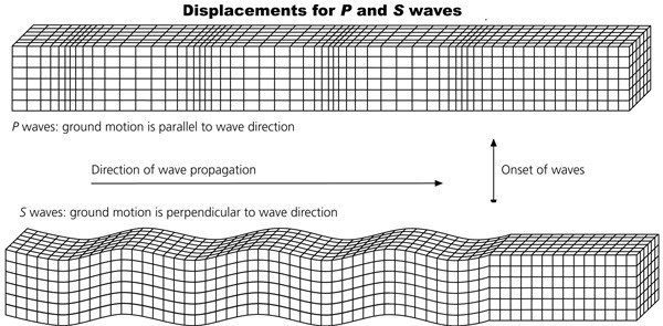
P waves:
These are called Primary Wave or Longitudinal Waves or Compression Waves, like Sound wave.It shakes things in the same direction it travels.The P wave can travel through solid, semi-solid and liquid i.e, crust, mantle and core.
S Waves:
These are the secondary waves and also known as transverse or shear waves. An S wave is slower than P wave and can only move through solid rocks. This wave moves rock up and down, or side-to-side i.e, rock vibrates perpendicular to the direction of wave propagation and much more destructive than P waves. Velocity of P wave is 1.7 times that of S wave.
Surface Waves:
Surface waves, in contrast to body waves can only move along the surface. They arrive after the main P and S waves and are confined to the outer layers of the Earth. They cause the most surface destruction. Earthquake surface waves are divided into two different categories:
Rayleigh Wave
Love Wave
Rayleigh Wave:
Rayleigh waves, also known as ground roll, spread through the ground as ripples, similar to rolling waves on the ocean. Like rolling ocean waves, Rayleigh waves move both vertically and horizontally in a vertical plane pointed in the direction in which the waves are travelling.Rayleigh waves are slower than body waves and typically travel at a speed that is 10% slower than S-waves.Love Wave:
Love waves have the same motion as S-waves but without the vertical displacement. They move the ground from side to side in a horizontal plane but at right angles to the direction of propagation. Love waves are particularly damaging to the foundations of structures because of the horizontal ground motion they generate. Love waves can also cause horizontal shearing of the ground. They usually travel slightly faster than Rayleigh waves, at a speed that is usually about 10% slower than S-waves, but like S-waves, they cannot spread through water.
| sno. | Body Waves | Surface Waves |
| 1 | They arrive before surface waves are emitted by an earthquake. | These waves are generated due to the effect of Body waves on earth surface |
| 2 | They are of higher frequency than surface waves. | They are of lower frequency than body waves. |
Causes Of Earthquake:
Tectonic Causes
Non tectonic causes
Tectonic Causes:
Earthquake is caused by faulting and folding in the crust due to tectonic activities.The mechanism of earthquake is well defined by the Elastic Rebound Theory.The earth is a dynamic body,the plates on the earth are moving continuously,due to which the rocks, at the plate boundaries, are continuously undergoing deformation. During the process of deformation of a plate, a great amount of stress is gradually exerted on the rock. When the stress exceeds the elastic limit, a fracture is developed.But the friction along the fracture resist the movement for certain time, when the stress exceeds the frictional resistance also, the block moves along a fault plane i.e, an accumulated energy is suddenly released and it travels through the earth shaking the earth's crust for a period of time.This concept of earthquake is called 'Elastic Rebound Theory'.
Non tectonic causes:
The earthquake may also occur due to collapse of subterrain cavaties and underground mines. The ground may shake due to large scale blasting and use of heavy machines as well as passing trains and tanks.Big landslides and avalanches are also responsible for ground tremor. Other reason may be the volcanic eruption and collapse of volcanic terrain.
Civil Engineering Consideration in Seismic Areas:
Seismic areas are the place which experience earthquake frequently. The civil engineers must think of making his construction immune to earthquakes. The difficulties in achieving this objectives are:
the exact place of earthquake (this is important because the epicenter region will be worst affected and hence needs maximum protection).
the magnitude of earthquake (this is important because the cost of construction increases with increases in safety required).
the duration of earthquake (this is important because the extent of damage will be more if duration is more).
the direction of movement of the ground at the time of earthquake.
The above mentioned factors are crucial because unless they are known, assessment of probable damage due to earthquake to civil engineering structures is not possible.
7. Explain Geotechnical Category Of Project.
Some of the Geotechnical categories can be explained under
Category 1
Category 2
Category 3
Category 1:
It involves relatively small structures.
Fundamental requirements will be satisfied on the basis of experience and qualitative geotechnical investigations.
There is negligible risk.
Geotechnical complexity is low.
Simplified design procedures applied.
Category 2:
It involves conventional types of structures.
There is no any exceptional risk.
Design includes quantitative geotechnical data and analysis for satisfying the fundamental requirements.
Category 3:
Structures which fall outside the limit of categories 1 and 2 fall within category 3 (Very large and unusual structures).
Structures in highly seismic areas.
It requires special measures and separate investigation.
Abnormal risks,or unusual ground conditions.
8. Explain various phase and tasks for evaluation of EGS.
Engineering geological studies have to be performed in different phases of any civil engineering projects.For avoiding unnecessary and excessive investment of time and money in order to get the required geotechnical information,Engineering geological studies are done systematically in the following phases:
Project definition,
Feasibility,
Design,
Construction,
Maintenance
The various parameters studied for the evaluation of EGS are:
the lithology of the intact rock.
Tectonics of the area.
Structural geology of the area.
Mechanical and physical properties of the rock mass.
Hydrogeological condition of the area.
The main phases of evaluation of EGS and the respective engineering Geological tasks are:
| Phase | Task for study |
| Project definition |
|
| pre-feasibility |
|
| Feasibility |
|
| Design |
|
| Construction |
|
| maintenance |
|
9. Write scope of Engineering Geology in field of Civil Engineering. [2068 Magh][2]
Some of the Scope of Geology in Civil Engineering can be explained as:
Geology provides necessary information about the lithology of the area and site construction materials that can be used in the construction of building dams, tunnels, highways, and bridges.
Geological information is most important in the planning phase, design phase, and construction phase of an engineering project.
Without structural geology study of the area, earthquake engineering studies cannot be performed and hence construction cannot be made immune to earthquakes.
The knowledge of geology helps to overcome and minimize the geology related risks that can be encountered during any civil engineering constructions.
Water resources engineering projects cannot be completed without hydrogeological study. The knowledge of groundwater is necessary in connection with irrigation, excavation works, water supply, etc.
10. What are main parameters of engineering geological system? [2068 Bhadra][2]
Engineering Geological System is defined as a system constituting of all the components and features forming the earth's crust.
Some components of engineering geological system are:
- Rocks
- Soils
- Geological structures
- Hydrological Bodies etc.
Rocks:
Naturally occurring solid aggregate made up of one or more minerals or mineraloids are known as Rocks.eg-Granite.
Soils:
Soil is the mixture of minerals, organic matter ,liquids, gases etc formed by the decomposition of rocks and deposition due to weathering and erosion.
Geological Structures:
The structural features like faults, folds, joints,etc that are formed in rocks due to permanent deformation and rock failure created by stresses through geologic time are called Geologic Structures.Geologic Structures are of following types:
- primary Structures:These are developed at the time of formation of the rocks (eg-Sedimentary Structures)
- Secondary Structures:These are developed in rocks after their formation as a result of their subjection to external forces (eg-Faults)
- Compound Structures:These are formed by the combination of events (eg- Unconformities).
Hydrogeological Bodies:
Hydrogeology is the branch of geology that deals with the distribution and movement of groundwater in the soil and rocks of the earth's crust.Aquifiers, rivers, etc are hydrogeological bodies.
The various parameters studied for the evaluation of EGS are:
- the lithology of the intact rock.
- Tectonics of the area.
- Structural geology of the area.
- Mechanical and physical properties of the rock mass.
- Hydrogeological condition of the area.